NAME ___________________
CLASS __________
DATE ____________________
BOONDOCKS, U.S.A.
BOONDOCKS, U.S.A.
1. Find the bench marks for each of the four (4) mountains on the map. Rank the mountains in order from smallest to tallest and give their relative benchmark elevation.
mountain benchmark elevation
#4. lowest __________________________ _________________
#3 _____________________________ __________________
#2 _____________________________ __________________
#1 highest___________________________ ___________________
2. What is the contour interval?____________________________________________
______________________________________________________________________
3. Note on the bottom of the map the words “true north” and the words “magnetic north”, what is the difference between these two phrases? ________________________
_______________________________________________________________________
4. Give the coordinates for the town of Rockville. _____________________
5. Give the coordinates for the town of Dixon. ________________________
6. In which direction does the Bark River run? ________________________
6a. What is the general rule about rivers and contours? _____________________
________________________________________________________________________
7. In which direction does the Roaring Stream run? ____________________
8. Using the map scale, what is the distance from the town of Norton to the edge of Blue Lake by taking the road?___________________________________________________
8a. How far would the same two locations be as the crow flies ( in a straight line)? _____________
9. Find the maximum and minimum elevation for the following points:
max min max min
Pt A _____________________ Pt C_______________________
Pt B _____________________ Pt D _______________________
10. Draw a profile from the fork of Roaring Stream to the top of Bear mountain.
Elev ‘
Contour lines marks
11. Calculate gradient for the above assuming Roaring Stream has an elevation of 125’.
Write the equation
Substitute numbers
Calculate and add proper units
12. Draw a 2nd profile from the top of Summit Hill to the top of Bald Peak.
Elev ‘
Contour lines marks
13. Calculate gradient from the town of Norton (assume elevation is 75’) to the top of Bald Peak.
Write the equation
Substitute numbers
Calculate and add proper units
14. How is a depression shown on the map?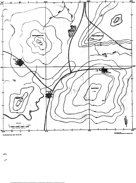
Back to top